Extras din proiect
Braila is one of the oldest cities in Romania, with a long and important history for the Romanian people.
ECONOMICAL DEVELOPMENT
Localization
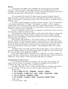
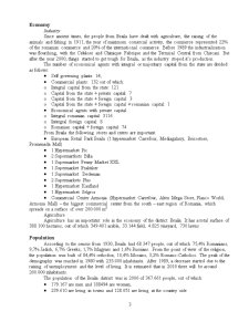
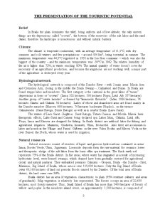
The city is situated at 46°16'17" north latitude and 27°58'33'' east longitude. Braila has as neighbors the Galati district at north, the Vrancea district at north-west, the Tulcea district at east, the Ialomita district at south and the Buzau district at west.
Braila district is situated in the south-east region, in the Romanian Plain. The district spreads on a surface of 4765.8 km2 – representing 2% of the total surface of Romania -, having 4 towns: Braila, Faurei, Ianca, Insuratei – the largest being Braila -, 140 villages and 40 communes: Baraganul, Bertestii de Jos, Bordei Verde, Chiscani, Ciocile, Ciresu, Cazasu, Dudesti, Frecatei, Galbenu, Gemenele, Gradistea, Gropeni, Jirlau, Marasu, Maxineni, Mircea Voda, Movila Miresii, Racovita, Rimnicelu, Romanu, Rosiori, Salcia Tudor, Scortaru Nou, Silistea, Surdila-Gaiseanca, Surdila-Greci, Şutesti, Tichilesti, Traian, Tudor Vladimirescu, Tufesti, Ulmu, Unirea, Vadeni, Victoria, Visani, Viziru, Zavoaia. The district’s residence is the Braila town, once one the biggest and most important harbors in Romania.
History
“The knowing of the realities from a communities life was and it will be fro the modern civilization a major preoccupation, with multiple implications both scientifically and civic. The monograph is a bow over time, an act of the birth of a town, from which the generations will be able to know their past and present, to build their future.” Gheorghe Serafimescu
The town started it’s life around 1350, when it started to appear in the ancient chronicles; though the evidence of the first person living in the area of Braila was dated 5000 bc, in the area of Brailita. It was certificated as an important residence of the “Tara Romaneasca” by Vladislav Vlaicu at 20 ianuarie 1368.
In an ancient Spanish geographical description and travel document - Libro Del Conoscimiento - it first appears under the name of "Drinago". It is mentioned as „Brayla” in 1368 in a privilege document given to the Brasov people traders. Braila was occupied by Turks between 1538 and 1540, and become a „raia” from 1554 to 1829, while it was called „Ibrail”. In the XV century it is mentioned as “Breil” in a document found in Transylvania.
The period of maximum prosperity was at the beginning of the XX century, when it become an important harbor, available for all kinds of ships.
The population from Braila though certified in the IV century didn’t disappear, it kept growing and it was found in the region between Chiscani and Baldovinesti. They did commerce with fish, which they sold to the Byzantines for gold; their good living was also due to the fact that the harbor was big and many ships came here.
Braila was first surely mentioned in 1481 by Stefan cel Mare, in a letter addressed to the aristocrats of Braila. The town had a major importance for all the traders, so the Turks didn’t change the name as they did to another town they conquered; but they built a fortress – fortress that didn’t last because was destroyed in the Russian – Turk war- which was composed by exterior walls – only a piece of it still exists high above the Danube platform – and by underground tunnels that are found across the city.
Only after 289 years and a tough war with the Turks, Braila managed to become again free and part of the Romanian territory. The city started growing bigger and bigger since then, due to the ships that come to the harbor and the agricultural possibilities.
Before Braila regained freedom, it had to face a lot of difficulties: the Turkish occupation, the wars the Turks gave to keep the fortress, the facts that it was burnt and rebuilt; so Braila was always an adaptable city, which managed to make all the peoples living there feel comfortable.
Transportation & ways of access
At 31 December 2006, Braila had 1186 public roads, out of which: 280 modernized; 264 national roads out of which 233 modernized; 923 district and communal roads out of which 74 modernized; the density of the public roads on 100 km2 was of 24.9.
The length of the public roads is of 1187 km and 280 modernized; the length of the railways is of 158 km; the length of the tram roads is of 53 km, the length of the gas pipe is of 233 km.
National roads:
- DN 21 Brăila (DN 2B) – Bărăganul – Slobozia – Călăraşi
- DN 2B Buzău – Surdila Greci – Ianca – Brăila – Baldovineşti – Galaţi
- DN 21A Slobozia – Bărăganul – Brăila
- DN 22 Buzău – Gradiştea – Brăila – (traversarea Dunării) Tulcea
District roads:
- DJ 221A Brăila – Galaţi
Preview document


Conținut arhivă zip
- Braila Tourism.doc
Alții au mai descărcat și

CAPITOLUL I 1.Poziţia geografică Judeţul Galaţi este situat în partea central-estică a ţării noastre, desfăşurându-se intre 45o25’ şi 46o10’...

1. Localizare si asezare Muntenia este o regiune istorica din sudul Romaniei. Limitele sale sunt: la nord muntii Carpati (care o delimiteaza de...

Braila, the city with acacia trees From the beginning we have to mention that this guide book is not meant to give to the tourist the official...

Fondul morfoturistic Apartine in intregime Podisului Moldovei, are un caracter pregnant sculptural, fiind alcatuit din platouri si dealuri...


CAP. I: NOTIUNI GENERALE PRIVIND AMENAJAREA TURISTICA A TERITORIULUI 1.1. Conceptul de amenajare turistica a unei zone Vitalitatea unui spaţiu...

CAP 1. TURISMUL DE LITORAL- CONCEPTE O privire de ansamblu asupra turismului de litoral ne conduce la identificarea anumitor tendinte: 1....

Turismul rural, ecologic si cultural în comuna Bran Pe baza experienteiternationale si a practicilor întâlnite în ultimii ani, în România sunt...
Te-ar putea interesa și

INTRODUCERE Turismul reprezinta o activitate permanenta a omului modern, având implicatii pe multiple planuri, de la cel economic la cel politic,...

1. Pozitia geografica a regiunii Sud Muntenia Muntenia este o regiune istorica din sudul Romaniei. Limitele sale sunt: la nord muntii Carpati...

I. Introduction I.1. Position géographique du département de Brăila Le département de Brăila se trouve au sud–est du pays dans la Plaine de...

Abstract The modern Romania was formed in 1866 through the union of two principalities sharing a common language and culture: Moldavia and...

Introducere Judeţul Timiş prin tradiţie, perseverenţă şi performanţele sale a devenit cel mai atractiv centru economic al României, un important...
1. Localizare si asezare Muntenia este o regiune istorica din sudul Romaniei. Limitele sale sunt: la nord muntii Carpati (care o delimiteaza de...

Turismul, forma de activitate umana destinata în principal odihnei si cunoasterii s-a impus în viata înca din cele mai vechi timpuri patrunzând cu...

Introducere Turismul reprezintă astăzi, prin conţinutul şi rolul său, un domeniu distinct de activitate, o componentă de primă importanţă a vieşii...